Kadarkút | |
|---|---|
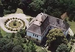 Somssich Mansion in Kadarkút | |
 Flag  Coat of arms | |
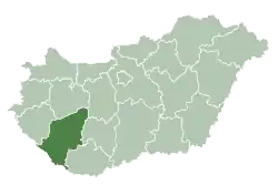
 Kadarkút Location of Kadarkút | |
| Coordinates: 46°13′54″N 17°37′10″E / 46.23156°N 17.61939°E | |
| Country | |
| Region | Southern Transdanubia |
| County | Somogy |
| District | Kaposvár |
| RC Diocese | Kaposvár |
| Area | |
| • Total | 39.74 km2 (15.34 sq mi) |
| Population (2017) | |
| • Total | 2,424[1] |
| Demonym | kadarkúti |
| Time zone | UTC+1 (CET) |
| • Summer (DST) | UTC+2 (CEST) |
| Postal code | 7530 |
| Area code | (+36) 82 |
| Patron Saint | Holy Trinity |
| NUTS 3 code | HU232 |
| MP | László Szászfalvi (KDNP) |
| Website | Kadarkút Online |
History
According to László Szita the settlement was completely Hungarian in the 18th century.[2]
Twin towns — sister cities
Kadarkút is twinned with:
 Veliko Trojstvo, Croatia (2006)
 Voitsberg, Austria (2008)
References
External links
- Official site of the town of Kadarkút
- Cultural Centre and Library (id. Kapoli Antal Művelődési Ház és Könyvtár)
- Kindergarten (Napköziotthonos Óvoda Kadarkút)
- Street map (in Hungarian)
This article is issued from Wikipedia. The text is licensed under Creative Commons - Attribution - Sharealike. Additional terms may apply for the media files.