Le Pin
| |
|---|---|
Commune | |
_-_%C3%A9glise.JPG.webp) | |
Location of Le Pin | |
 Le Pin 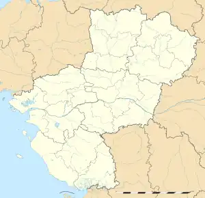 Le Pin | |
| Coordinates: 47°35′24″N 1°09′08″W / 47.59°N 1.1522°W | |
| Country | France |
| Region | Pays de la Loire |
| Department | Loire-Atlantique |
| Arrondissement | Châteaubriant-Ancenis |
| Canton | Ancenis-Saint-Géréon |
| Intercommunality | Pays d'Ancenis |
| Government | |
| • Mayor (2020–2026) | Maxime Poupart[1] |
| Area 1 | 24.95 km2 (9.63 sq mi) |
| Population | 790 |
| • Density | 32/km2 (82/sq mi) |
| Time zone | UTC+01:00 (CET) |
| • Summer (DST) | UTC+02:00 (CEST) |
| INSEE/Postal code | 44124 /44540 |
| Elevation | 39–91 m (128–299 ft) |
| 1 French Land Register data, which excludes lakes, ponds, glaciers > 1 km2 (0.386 sq mi or 247 acres) and river estuaries. | |
Le Pin (French pronunciation: [lə pɛ̃] ⓘ; Gallo: Le Pein or L'Piñ, Breton: Ar Bineg) is a commune in the Arrondissement of Châteaubriant-Ancenis of the Loire-Atlantique department in western France. It is located between Rennes and Angers, in the drainage basin of the Erdre, a right tributary of the Loire.
Population
| Year | Pop. | ±% p.a. |
|---|---|---|
| 1968 | 752 | — |
| 1975 | 698 | −1.06% |
| 1982 | 680 | −0.37% |
| 1990 | 602 | −1.51% |
| 1999 | 602 | +0.00% |
| 2007 | 692 | +1.76% |
| 2012 | 792 | +2.74% |
| 2017 | 754 | −0.98% |
| Source: INSEE[3] | ||
See also
References
- ↑ "Répertoire national des élus: les maires" (in French). data.gouv.fr, Plateforme ouverte des données publiques françaises. 13 September 2022.
- ↑ "Populations légales 2021". The National Institute of Statistics and Economic Studies. 28 December 2023.
- ↑ Population en historique depuis 1968, INSEE
Wikimedia Commons has media related to Le Pin (Loire-Atlantique).
This article is issued from Wikipedia. The text is licensed under Creative Commons - Attribution - Sharealike. Additional terms may apply for the media files.