Macotera | |
|---|---|
 Flag  Coat of arms | |
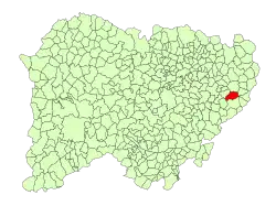 Location in Salamanca | |
| Coordinates: 40°50′N 5°17′W / 40.833°N 5.283°W | |
| Country | Spain |
| Autonomous community | Castile and León |
| Province | Salamanca |
| Comarca | Tierra de Peñaranda |
| Government | |
| • Mayor | Francisco Bláquez Sánchez |
| Area | |
| • Total | 33 km2 (13 sq mi) |
| Elevation | 892 m (2,927 ft) |
| Population (2018)[2] | |
| • Total | 1,085 |
| • Density | 33/km2 (85/sq mi) |
| Demonym | Macoterano |
| Time zone | UTC+1 (CET) |
| • Summer (DST) | UTC+2 (CEST) |
| Postal code | 37310 |
| Distances |
|
| Rivers | River Margañán |
Macotera is a village and municipality in the province of Salamanca, western Spain, part of the autonomous community of Castile-Leon. It is located 50 kilometres (31 mi) from the capital city of Salamanca.
See also
References
- 1 2 "Municipio:Macotera". www.lasalina.es (in Spanish). Retrieved 2017-11-06.
- ↑ Municipal Register of Spain 2018. National Statistics Institute.
External links
- Ruidoso pleito entre Macotera y Santiago de la Puebla en el siglo XVI (exhumación del documento antiguo)
- Diputación de Salamanca: Índice de municipios
- Diputación de Salamanca: Macotera
- Diputación de Salamanca: Datos de Macotera
- Macotera at Curlie
- Macotera en Google Maps
This article is issued from Wikipedia. The text is licensed under Creative Commons - Attribution - Sharealike. Additional terms may apply for the media files.