Sanchotello | |
|---|---|
 Flag  Seal | |
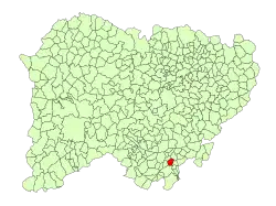 Location in Salamanca | |
 Sanchotello Location in Spain | |
| Coordinates: 40°26′17″N 5°45′10″W / 40.43806°N 5.75278°W | |
| Country | Spain |
| Autonomous community | Castile and León |
| Province | Salamanca |
| Comarca | Sierra de Béjar |
| Government | |
| • Mayor | Fernando Balsa (People's Party) |
| Area | |
| • Total | 14 km2 (5 sq mi) |
| Elevation | 936 m (3,071 ft) |
| Population (2018)[2] | |
| • Total | 222 |
| • Density | 16/km2 (41/sq mi) |
| Time zone | UTC+1 (CET) |
| • Summer (DST) | UTC+2 (CEST) |
| Postal code | 37794 |
Sanchotello is a municipality located in the province of Salamanca, Castile and León, Spain. As of 2016 the municipality has a population of 227 inhabitants.[3]
References
- 1 2 "Municipio:Sanchotello". www.lasalina.es (in Spanish). Retrieved 2017-11-01.
- ↑ Municipal Register of Spain 2018. National Statistics Institute.
- ↑ "Salamanca: Población por municipios y sexo". www.ine.es (in Spanish). Retrieved 2017-11-01.
This article is issued from Wikipedia. The text is licensed under Creative Commons - Attribution - Sharealike. Additional terms may apply for the media files.