Semondans | |
|---|---|
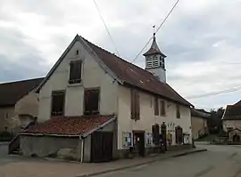 The town hall and school in Semondans | |
 Coat of arms | |
Location of Semondans | |
 Semondans  Semondans | |
| Coordinates: 47°32′37″N 6°41′37″E / 47.5436°N 6.6936°E | |
| Country | France |
| Region | Bourgogne-Franche-Comté |
| Department | Doubs |
| Arrondissement | Montbéliard |
| Canton | Bavans |
| Intercommunality | Pays de Montbéliard Agglomération |
| Government | |
| • Mayor (2020–2026) | Pascal Pavillard[1] |
| Area 1 | 2.77 km2 (1.07 sq mi) |
| Population | 312 |
| • Density | 110/km2 (290/sq mi) |
| Time zone | UTC+01:00 (CET) |
| • Summer (DST) | UTC+02:00 (CEST) |
| INSEE/Postal code | 25540 /25750 |
| Elevation | 344–450 m (1,129–1,476 ft) |
| 1 French Land Register data, which excludes lakes, ponds, glaciers > 1 km2 (0.386 sq mi or 247 acres) and river estuaries. | |
Semondans (French pronunciation: [səmɔ̃dɑ̃]) is a commune in the Doubs department in the Bourgogne-Franche-Comté region in eastern France.
Geography
Semondan lies 8.5 km (5.3 mi) southwest of Montbéliard. The Rupt flows through the commune.
Population
| Year | Pop. | ±% |
|---|---|---|
| 1962 | 109 | — |
| 1968 | 128 | +17.4% |
| 1975 | 235 | +83.6% |
| 1982 | 230 | −2.1% |
| 1990 | 233 | +1.3% |
| 1999 | 236 | +1.3% |
| 2008 | 320 | +35.6% |
| 2012 | 306 | −4.4% |
See also
References
- ↑ "Répertoire national des élus: les maires" (in French). data.gouv.fr, Plateforme ouverte des données publiques françaises. 13 September 2022.
- ↑ "Populations légales 2021". The National Institute of Statistics and Economic Studies. 28 December 2023.
External links
Wikimedia Commons has media related to Semondans.
- Semondans on the regional Web site (in French)
This article is issued from Wikipedia. The text is licensed under Creative Commons - Attribution - Sharealike. Additional terms may apply for the media files.