Terragnolo | |
|---|---|
| Comune di Terragnolo | |
Location of Terragnolo | |
 Terragnolo Location of Terragnolo in Italy 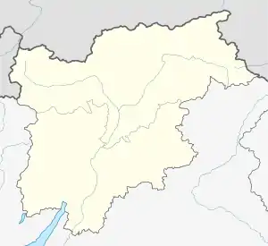 Terragnolo Terragnolo (Trentino-Alto Adige/Südtirol) | |
| Coordinates: 45°53′N 11°9′E / 45.883°N 11.150°E | |
| Country | Italy |
| Region | Trentino-Alto Adige/Südtirol |
| Province | Trentino (TN) |
| Government | |
| • Mayor | Lorenzo Galletti |
| Area | |
| • Total | 39.4 km2 (15.2 sq mi) |
| Elevation | 785 m (2,575 ft) |
| Population (30.04.2020)[2] | |
| • Total | 692 |
| • Density | 18/km2 (45/sq mi) |
| Demonym | Terragnoli |
| Time zone | UTC+1 (CET) |
| • Summer (DST) | UTC+2 (CEST) |
| Postal code | 38060 |
| Dialing code | 0464 |
| Website | Official website |
Terragnolo (Cimbrian: Leimtal) is a comune (municipality) in Trentino in the northern Italian region Trentino-Alto Adige/Südtirol, located about 20 kilometres (12 mi) south of Trento.
Terragnolo borders the following municipalities: Folgaria, Rovereto, Trambileno, Laghi and Posina.
References
- ↑ "Superficie di Comuni Province e Regioni italiane al 9 ottobre 2011". Italian National Institute of Statistics. Retrieved 16 March 2019.
- ↑ "Statistiche demografiche ISTAT".
External links
This article is issued from Wikipedia. The text is licensed under Creative Commons - Attribution - Sharealike. Additional terms may apply for the media files.