Villerouge-Termenès | |
|---|---|
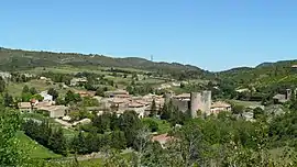 A general view of Villerouge | |
 Coat of arms | |
Location of Villerouge-Termenès | |
 Villerouge-Termenès  Villerouge-Termenès | |
| Coordinates: 43°00′28″N 2°37′44″E / 43.0078°N 2.6289°E | |
| Country | France |
| Region | Occitania |
| Department | Aude |
| Arrondissement | Narbonne |
| Canton | Les Corbières |
| Government | |
| • Mayor (2020–2026) | Michel Ponçot[1] |
| Area 1 | 19.41 km2 (7.49 sq mi) |
| Population | 158 |
| • Density | 8.1/km2 (21/sq mi) |
| Time zone | UTC+01:00 (CET) |
| • Summer (DST) | UTC+02:00 (CEST) |
| INSEE/Postal code | 11435 /11330 |
| Elevation | 272–620 m (892–2,034 ft) (avg. 325 m or 1,066 ft) |
| 1 French Land Register data, which excludes lakes, ponds, glaciers > 1 km2 (0.386 sq mi or 247 acres) and river estuaries. | |
Villerouge-Termenès (French pronunciation: [vilʁuʒ tɛʁmənɛs] ⓘ; Languedocien: Vilaroja de Termenés) is a commune in the Aude department in southern France.
Population
| Year | Pop. | ±% p.a. |
|---|---|---|
| 1968 | 176 | — |
| 1975 | 140 | −3.22% |
| 1982 | 146 | +0.60% |
| 1990 | 154 | +0.67% |
| 1999 | 158 | +0.29% |
| 2009 | 155 | −0.19% |
| 2014 | 139 | −2.16% |
| 2020 | 157 | +2.05% |
| Source: INSEE[3] | ||
See also
References
- ↑ "Répertoire national des élus: les maires". data.gouv.fr, Plateforme ouverte des données publiques françaises (in French). 9 August 2021.
- ↑ "Populations légales 2021". The National Institute of Statistics and Economic Studies. 28 December 2023.
- ↑ Population en historique depuis 1968, INSEE
Wikimedia Commons has media related to Villerouge-Termenès.
This article is issued from Wikipedia. The text is licensed under Creative Commons - Attribution - Sharealike. Additional terms may apply for the media files.