Antheuil | |
|---|---|
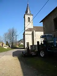 San Antide Church | |
.svg.png.webp) Coat of arms | |
Location of Antheuil | |
 Antheuil  Antheuil | |
| Coordinates: 47°10′24″N 4°44′47″E / 47.1733°N 4.7464°E | |
| Country | France |
| Region | Bourgogne-Franche-Comté |
| Department | Côte-d'Or |
| Arrondissement | Beaune |
| Canton | Arnay-le-Duc |
| Intercommunality | Pouilly-en-Auxois/Bligny-sur-Ouche |
| Government | |
| • Mayor (2020–2026) | Martine Seguin[1] |
| Area 1 | 10.28 km2 (3.97 sq mi) |
| Population | 62 |
| • Density | 6.0/km2 (16/sq mi) |
| Time zone | UTC+01:00 (CET) |
| • Summer (DST) | UTC+02:00 (CEST) |
| INSEE/Postal code | 21014 /21360 |
| Elevation | 345–613 m (1,132–2,011 ft) (avg. 510 m or 1,670 ft) |
| 1 French Land Register data, which excludes lakes, ponds, glaciers > 1 km2 (0.386 sq mi or 247 acres) and river estuaries. | |
Antheuil (French pronunciation: [ɑ̃tœj]) is a commune in the Côte-d'Or department in the Bourgogne-Franche-Comté region of eastern France.
Geography
Antheuil is located some 40 km south-west of Dijon and 25 km north-west of Beaune. It can be accessed by the minor D115 road running north from the D18 road passing through the village and continuing north-west to join the D33. The commune is hilly and heavily forested.
The Antheuil river rises south of the village and flows north-west to join the Ouche near Veuvey-sur-Ouche.[3]
Neighbouring communes and villages
Places adjacent to Antheuil | |
|---|---|
Heraldry
Arms of Antheuil |
Blazon: Gules, two lances of Or saltirewise debruised by a stone tablet in Argent charged with lines in sable; in chief wavy of Azure soutenu in Argent charged with three daisies of Or.
|
Administration
List of Successive Mayors[4]
| From | To | Name |
|---|---|---|
| 1945 | 1965 | Théophile Maurice Gauthier |
| ? | 2001 | Jean Anus |
| 2001 | 2008 | Jean-Claude Lebreuil |
| 2008 | 2014 | Michel Lefort |
| 2014 | 2026 | Martine Seguin |
Demography
In 2017 the commune had 60 inhabitants.
|
| ||||||||||||||||||||||||||||||||||||||||||||||||||||||||||||||||||||||||||||||||||||||||||||||||||||||||||||||||||
| Source: EHESS[5] and INSEE[6] | |||||||||||||||||||||||||||||||||||||||||||||||||||||||||||||||||||||||||||||||||||||||||||||||||||||||||||||||||||
Sites and monuments
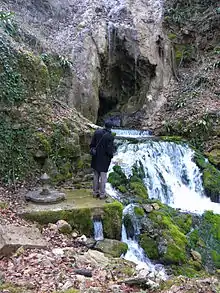
- Le Bel Affeux, a picturesque stream
- La Roche percée (Pierced rock), a hill in the east
- La Roche des Demoiselles (Young ladies' rock), a hill in the west
- La Roche plate (Flat rock)
- The Château Mignon
- The Parish Church of Saint-Antide contains two items t5hat are registered as historical objects:
See also
References
- ↑ "Répertoire national des élus: les maires". data.gouv.fr, Plateforme ouverte des données publiques françaises (in French). 2 December 2020.
- ↑ "Populations légales 2021". The National Institute of Statistics and Economic Studies. 28 December 2023.
- 1 2 Google Maps
- ↑ List of Mayors of France
- ↑ Des villages de Cassini aux communes d'aujourd'hui: Commune data sheet Antheuil, EHESS (in French).
- ↑ Population en historique depuis 1968, INSEE
- ↑ Ministry of Culture, Palissy PM21000032 Statue: Virgin and child (in French)

- ↑ Ministry of Culture, Palissy PM21000031 Stoup (in French)
External links
- Canton of Bligny sur Ouche official website (in French)
- Antheuil on the National Geographic Institute website (in French)
- Antheuil on Géoportail, National Geographic Institute (IGN) website (in French)
- Antheuil on the 1750 Cassini Map