Montceau-et-Écharnant | |
|---|---|
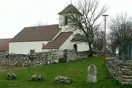 The chapel of Écharnant | |
.svg.png.webp) Coat of arms | |
Location of Montceau-et-Écharnant | |
 Montceau-et-Écharnant  Montceau-et-Écharnant | |
| Coordinates: 47°03′41″N 4°39′32″E / 47.0614°N 4.6589°E | |
| Country | France |
| Region | Bourgogne-Franche-Comté |
| Department | Côte-d'Or |
| Arrondissement | Beaune |
| Canton | Arnay-le-Duc |
| Government | |
| • Mayor (2020–2026) | Pascal Janiszewski[1] |
| Area 1 | 18.58 km2 (7.17 sq mi) |
| Population | 185 |
| • Density | 10.0/km2 (26/sq mi) |
| Time zone | UTC+01:00 (CET) |
| • Summer (DST) | UTC+02:00 (CEST) |
| INSEE/Postal code | 21427 /21360 |
| Elevation | 379–551 m (1,243–1,808 ft) (avg. 509 m or 1,670 ft) |
| 1 French Land Register data, which excludes lakes, ponds, glaciers > 1 km2 (0.386 sq mi or 247 acres) and river estuaries. | |
Montceau-et-Écharnant (French pronunciation: [mɔ̃so e eʃaʁnɑ̃]) is a commune in the Côte-d'Or department in eastern France.
Population
| Year | Pop. | ±% |
|---|---|---|
| 1962 | 107 | — |
| 1968 | 143 | +33.6% |
| 1975 | 126 | −11.9% |
| 1982 | 121 | −4.0% |
| 1990 | 118 | −2.5% |
| 1999 | 121 | +2.5% |
| 2008 | 152 | +25.6% |
See also
References
- ↑ "Répertoire national des élus: les maires" (in French). data.gouv.fr, Plateforme ouverte des données publiques françaises. 13 September 2022.
- ↑ "Populations légales 2021". The National Institute of Statistics and Economic Studies. 28 December 2023.
Wikimedia Commons has media related to Montceau-et-Écharnant.
This article is issued from Wikipedia. The text is licensed under Creative Commons - Attribution - Sharealike. Additional terms may apply for the media files.