Til-Châtel | |
|---|---|
.jpg.webp) The road through Til-Châtel | |
.svg.png.webp) Coat of arms | |
Location of Til-Châtel | |
 Til-Châtel  Til-Châtel | |
| Coordinates: 47°31′07″N 5°10′31″E / 47.5186°N 5.1753°E | |
| Country | France |
| Region | Bourgogne-Franche-Comté |
| Department | Côte-d'Or |
| Arrondissement | Dijon |
| Canton | Is-sur-Tille |
| Government | |
| • Mayor (2020–2026) | Alain Gradelet[1] |
| Area 1 | 26.37 km2 (10.18 sq mi) |
| Population | 1,158 |
| • Density | 44/km2 (110/sq mi) |
| Time zone | UTC+01:00 (CET) |
| • Summer (DST) | UTC+02:00 (CEST) |
| INSEE/Postal code | 21638 /21120 |
| Elevation | 256–349 m (840–1,145 ft) (avg. 273 m or 896 ft) |
| 1 French Land Register data, which excludes lakes, ponds, glaciers > 1 km2 (0.386 sq mi or 247 acres) and river estuaries. | |
Til-Châtel (French pronunciation: [til ʃɑˈtɛl]) is a commune of the Côte-d'Or department in eastern France.
Population
| Year | Pop. | ±% |
|---|---|---|
| 1962 | 717 | — |
| 1968 | 731 | +2.0% |
| 1975 | 735 | +0.5% |
| 1982 | 755 | +2.7% |
| 1990 | 768 | +1.7% |
| 1999 | 819 | +6.6% |
| 2008 | 974 | +18.9% |
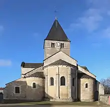
Church Saint-Florent-et-Saint-Honoré (12th century)
See also
References
- ↑ "Répertoire national des élus: les maires" (in French). data.gouv.fr, Plateforme ouverte des données publiques françaises. 13 September 2022.
- ↑ "Populations légales 2021". The National Institute of Statistics and Economic Studies. 28 December 2023.
Wikimedia Commons has media related to Til-Châtel.
This article is issued from Wikipedia. The text is licensed under Creative Commons - Attribution - Sharealike. Additional terms may apply for the media files.