Englesqueville-la-Percée | |
|---|---|
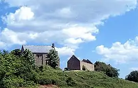 Chateau of Beaumont-le-Richard | |
Location of Englesqueville-la-Percée | |
 Englesqueville-la-Percée  Englesqueville-la-Percée | |
| Coordinates: 49°22′36″N 0°57′02″W / 49.3767°N 0.9506°W | |
| Country | France |
| Region | Normandy |
| Department | Calvados |
| Arrondissement | Bayeux |
| Canton | Trévières |
| Intercommunality | CC Isigny-Omaha Intercom |
| Government | |
| • Mayor (2020–2026) | Dominique Legrand[1] |
| Area 1 | 7.88 km2 (3.04 sq mi) |
| Population | 98 |
| • Density | 12/km2 (32/sq mi) |
| Time zone | UTC+01:00 (CET) |
| • Summer (DST) | UTC+02:00 (CEST) |
| INSEE/Postal code | 14239 /14710 |
| Elevation | 0–42 m (0–138 ft) (avg. 30 m or 98 ft) |
| 1 French Land Register data, which excludes lakes, ponds, glaciers > 1 km2 (0.386 sq mi or 247 acres) and river estuaries. | |
Englesqueville-la-Percée is a commune in the Calvados department in the Normandy region in northwestern France.
Population
| Year | Pop. | ±% |
|---|---|---|
| 1962 | 191 | — |
| 1968 | 180 | −5.8% |
| 1975 | 158 | −12.2% |
| 1982 | 121 | −23.4% |
| 1990 | 125 | +3.3% |
| 1999 | 97 | −22.4% |
| 2008 | 90 | −7.2% |
See also
References
- ↑ "Répertoire national des élus: les maires". data.gouv.fr, Plateforme ouverte des données publiques françaises (in French). 9 August 2021.
- ↑ "Populations légales 2021". The National Institute of Statistics and Economic Studies. 28 December 2023.
Wikimedia Commons has media related to Englesqueville-la-Percée.
This article is issued from Wikipedia. The text is licensed under Creative Commons - Attribution - Sharealike. Additional terms may apply for the media files.