Longues-sur-Mer | |
|---|---|
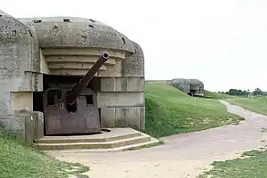 Two bunkers of the Longues-sur-Mer battery | |
 Coat of arms | |
Location of Longues-sur-Mer | |
 Longues-sur-Mer  Longues-sur-Mer | |
| Coordinates: 49°20′12″N 0°41′39″W / 49.3367°N 0.6942°W | |
| Country | France |
| Region | Normandy |
| Department | Calvados |
| Arrondissement | Bayeux |
| Canton | Bayeux |
| Government | |
| • Mayor (2020–2026) | Roland Tirard[1] |
| Area 1 | 12.29 km2 (4.75 sq mi) |
| Population | 586 |
| • Density | 48/km2 (120/sq mi) |
| Time zone | UTC+01:00 (CET) |
| • Summer (DST) | UTC+02:00 (CEST) |
| INSEE/Postal code | 14377 /14400 |
| Elevation | 0–77 m (0–253 ft) (avg. 76 m or 249 ft) |
| 1 French Land Register data, which excludes lakes, ponds, glaciers > 1 km2 (0.386 sq mi or 247 acres) and river estuaries. | |
Longues-sur-Mer (French pronunciation: [lɔ̃ɡ syʁ mɛʁ] ⓘ) is a commune in the Calvados department in Normandie region in northwestern France.
The Longues-sur-Mer battery is nearby, part of the Atlantic Wall coastal fortifications.
Population
| Year | Pop. | ±% |
|---|---|---|
| 1962 | 466 | — |
| 1968 | 469 | +0.6% |
| 1975 | 447 | −4.7% |
| 1982 | 463 | +3.6% |
| 1990 | 561 | +21.2% |
| 1999 | 586 | +4.5% |
| 2008 | 674 | +15.0% |
See also
References
- ↑ "Répertoire national des élus: les maires". data.gouv.fr, Plateforme ouverte des données publiques françaises (in French). 2 December 2020.
- ↑ "Populations légales 2021". The National Institute of Statistics and Economic Studies. 28 December 2023.
External links
Wikimedia Commons has media related to Longues-sur-Mer.
This article is issued from Wikipedia. The text is licensed under Creative Commons - Attribution - Sharealike. Additional terms may apply for the media files.