Lederzeele
Lederzele | |
|---|---|
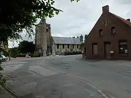 The church in Lederzeele | |
_Nord-France.svg.png.webp) Coat of arms | |
Location of Lederzeele | |
 Lederzeele  Lederzeele | |
| Coordinates: 50°49′21″N 2°18′01″E / 50.8225°N 2.3003°E | |
| Country | France |
| Region | Hauts-de-France |
| Department | Nord |
| Arrondissement | Dunkirk |
| Canton | Wormhout |
| Intercommunality | Hauts de Flandre |
| Government | |
| • Mayor (2020–2026) | Michel Delforge[1] |
| Area 1 | 8.64 km2 (3.34 sq mi) |
| Population | 692 |
| • Density | 80/km2 (210/sq mi) |
| Demonym | Lederzeelois |
| Time zone | UTC+01:00 (CET) |
| • Summer (DST) | UTC+02:00 (CEST) |
| INSEE/Postal code | 59337 /59143 |
| Elevation | 4–41 m (13–135 ft) (avg. 33 m or 108 ft) |
| 1 French Land Register data, which excludes lakes, ponds, glaciers > 1 km2 (0.386 sq mi or 247 acres) and river estuaries. | |
Lederzeele (from Flemish; Lederzele in modern Dutch spelling) is a commune in the Nord department in northern France.[3]
It is 10 km (6.2 mi) northeast of Saint-Omer.
Heraldry
Arms of Lederzeele |
The arms of Lederzeele are blazoned : Azure billetty, on a bend Or 3 martlets gules.
|
See also
References
- ↑ "Répertoire national des élus: les maires". data.gouv.fr, Plateforme ouverte des données publiques françaises (in French). 2 December 2020.
- ↑ "Populations légales 2021". The National Institute of Statistics and Economic Studies. 28 December 2023.
- ↑ INSEE commune file
Wikimedia Commons has media related to Lederzeele.
This article is issued from Wikipedia. The text is licensed under Creative Commons - Attribution - Sharealike. Additional terms may apply for the media files.