Saint-Aulais-la-Chapelle | |
|---|---|
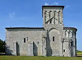 The church of Conzac | |
Location of Saint-Aulais-la-Chapelle | |
 Saint-Aulais-la-Chapelle  Saint-Aulais-la-Chapelle | |
| Coordinates: 45°26′56″N 0°02′54″W / 45.4489°N 0.0483°W | |
| Country | France |
| Region | Nouvelle-Aquitaine |
| Department | Charente |
| Arrondissement | Cognac |
| Canton | Charente-Sud |
| Intercommunality | 4B Sud-Charente |
| Government | |
| • Mayor (2020–2026) | Patrick Huneau[1] |
| Area 1 | 14.84 km2 (5.73 sq mi) |
| Population | 226 |
| • Density | 15/km2 (39/sq mi) |
| Time zone | UTC+01:00 (CET) |
| • Summer (DST) | UTC+02:00 (CEST) |
| INSEE/Postal code | 16301 /16300 |
| Elevation | 60–128 m (197–420 ft) (avg. 65 m or 213 ft) |
| 1 French Land Register data, which excludes lakes, ponds, glaciers > 1 km2 (0.386 sq mi or 247 acres) and river estuaries. | |
Saint-Aulais-la-Chapelle is a commune in the Charente department in southwestern France.
Population
| Year | Pop. | ±% p.a. |
|---|---|---|
| 1968 | 350 | — |
| 1975 | 325 | −1.05% |
| 1982 | 294 | −1.42% |
| 1990 | 264 | −1.34% |
| 1999 | 233 | −1.38% |
| 2009 | 228 | −0.22% |
| 2014 | 235 | +0.61% |
| 2020 | 226 | −0.65% |
| Source: INSEE[3] | ||
See also
References
- ↑ "Répertoire national des élus: les maires". data.gouv.fr, Plateforme ouverte des données publiques françaises (in French). 2 December 2020.
- ↑ "Populations légales 2021". The National Institute of Statistics and Economic Studies. 28 December 2023.
- ↑ Population en historique depuis 1968, INSEE
Wikimedia Commons has media related to Saint-Aulais-la-Chapelle.
This article is issued from Wikipedia. The text is licensed under Creative Commons - Attribution - Sharealike. Additional terms may apply for the media files.