Saint-Laurent-sur-Mer | |
|---|---|
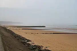 Omaha Beach | |
Location of Saint-Laurent-sur-Mer | |
 Saint-Laurent-sur-Mer  Saint-Laurent-sur-Mer | |
| Coordinates: 49°21′34″N 0°52′35″W / 49.3594°N 0.8764°W | |
| Country | France |
| Region | Normandy |
| Department | Calvados |
| Arrondissement | Bayeux |
| Canton | Trévières |
| Intercommunality | CC Isigny-Omaha Intercom |
| Government | |
| • Mayor (2020–2026) | Denis Madouasse[1] |
| Area 1 | 3.9 km2 (1.5 sq mi) |
| Population | 256 |
| • Density | 66/km2 (170/sq mi) |
| Time zone | UTC+01:00 (CET) |
| • Summer (DST) | UTC+02:00 (CEST) |
| INSEE/Postal code | 14605 /14710 |
| Elevation | 3–76 m (9.8–249.3 ft) (avg. 30 m or 98 ft) |
| 1 French Land Register data, which excludes lakes, ponds, glaciers > 1 km2 (0.386 sq mi or 247 acres) and river estuaries. | |
Saint-Laurent-sur-Mer (French pronunciation: [sɛ̃ loʁɑ̃ syʁ mɛʁ] ⓘ, literally Saint-Laurent on Sea) is a commune in the Calvados department in the Normandy region in northwestern France. The town is located not far from Omaha Beach, where, in World War II, Allied forces landed during D-Day.
It was also the location of a British Commando raid - Operation Curlew during January 1942.
Population
| Year | Pop. | ±% |
|---|---|---|
| 1962 | 199 | — |
| 1968 | 174 | −12.6% |
| 1975 | 161 | −7.5% |
| 1982 | 188 | +16.8% |
| 1990 | 163 | −13.3% |
| 1999 | 184 | +12.9% |
| 2008 | 242 | +31.5% |
See also
References
- ↑ "Répertoire national des élus: les maires". data.gouv.fr, Plateforme ouverte des données publiques françaises (in French). 9 August 2021.
- ↑ "Populations légales 2021". The National Institute of Statistics and Economic Studies. 28 December 2023.
Wikimedia Commons has media related to Saint-Laurent-sur-Mer.
This article is issued from Wikipedia. The text is licensed under Creative Commons - Attribution - Sharealike. Additional terms may apply for the media files.