Condom-d'Aubrac | |
|---|---|
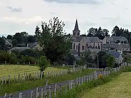 The church and surrounding buildings in Condom-d'Aubrac | |
.svg.png.webp) Coat of arms | |
Location of Condom-d'Aubrac | |
 Condom-d'Aubrac  Condom-d'Aubrac | |
| Coordinates: 44°36′16″N 2°51′58″E / 44.6044°N 2.8661°E | |
| Country | France |
| Region | Occitania |
| Department | Aveyron |
| Arrondissement | Rodez |
| Canton | Aubrac et Carladez |
| Government | |
| • Mayor (2020–2026) | Geneviève Gasq-Barès[1] |
| Area 1 | 46.08 km2 (17.79 sq mi) |
| Population | 291 |
| • Density | 6.3/km2 (16/sq mi) |
| Time zone | UTC+01:00 (CET) |
| • Summer (DST) | UTC+02:00 (CEST) |
| INSEE/Postal code | 12074 /12470 |
| Elevation | 465–1,440 m (1,526–4,724 ft) (avg. 950 m or 3,120 ft) |
| 1 French Land Register data, which excludes lakes, ponds, glaciers > 1 km2 (0.386 sq mi or 247 acres) and river estuaries. | |
Condom-d'Aubrac (French pronunciation: [kɔ̃dɔ̃ dobʁak]; Occitan: Condom d'Aubrac) is a commune in the Aveyron department in southern France.
Population
| Year | Pop. | ±% p.a. |
|---|---|---|
| 1968 | 471 | — |
| 1975 | 382 | −2.95% |
| 1982 | 336 | −1.82% |
| 1990 | 349 | +0.48% |
| 1999 | 349 | +0.00% |
| 2009 | 317 | −0.96% |
| 2014 | 304 | −0.83% |
| 2020 | 292 | −0.67% |
| Source: INSEE[3] | ||
See also
References
- ↑ "Répertoire national des élus: les maires". data.gouv.fr, Plateforme ouverte des données publiques françaises (in French). 2 December 2020.
- ↑ "Populations légales 2021". The National Institute of Statistics and Economic Studies. 28 December 2023.
- ↑ Population en historique depuis 1968, INSEE
Wikimedia Commons has media related to Condom-d'Aubrac.
This article is issued from Wikipedia. The text is licensed under Creative Commons - Attribution - Sharealike. Additional terms may apply for the media files.