Sylvanès | |
|---|---|
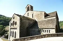 Abbey church | |
Location of Sylvanès | |
 Sylvanès  Sylvanès | |
| Coordinates: 43°50′03″N 2°57′33″E / 43.8342°N 2.9592°E | |
| Country | France |
| Region | Occitania |
| Department | Aveyron |
| Arrondissement | Millau |
| Canton | Causses-Rougiers |
| Government | |
| • Mayor (2020–2026) | Michel Wolkowicki[1] |
| Area 1 | 16.96 km2 (6.55 sq mi) |
| Population | 115 |
| • Density | 6.8/km2 (18/sq mi) |
| Time zone | UTC+01:00 (CET) |
| • Summer (DST) | UTC+02:00 (CEST) |
| INSEE/Postal code | 12274 /12360 |
| Elevation | 399–780 m (1,309–2,559 ft) (avg. 432 m or 1,417 ft) |
| 1 French Land Register data, which excludes lakes, ponds, glaciers > 1 km2 (0.386 sq mi or 247 acres) and river estuaries. | |
Sylvanès (French pronunciation: [silvanɛs]; Occitan: Silvanés) is a commune in the Aveyron department in southern France.
Geography
The Dourdou de Camarès forms part of the commune's southern border.
Population
| Year | Pop. | ±% p.a. |
|---|---|---|
| 1968 | 144 | — |
| 1975 | 109 | −3.90% |
| 1982 | 117 | +1.02% |
| 1990 | 108 | −1.00% |
| 1999 | 117 | +0.89% |
| 2009 | 91 | −2.48% |
| 2014 | 105 | +2.90% |
| 2020 | 114 | +1.38% |
| Source: INSEE[3] | ||
See also
References
- ↑ "Répertoire national des élus: les maires". data.gouv.fr, Plateforme ouverte des données publiques françaises (in French). 2 December 2020.
- ↑ "Populations légales 2021". The National Institute of Statistics and Economic Studies. 28 December 2023.
- ↑ Population en historique depuis 1968, INSEE
External links
Wikimedia Commons has media related to Sylvanès.
This article is issued from Wikipedia. The text is licensed under Creative Commons - Attribution - Sharealike. Additional terms may apply for the media files.