Sainte-Radegonde | |
|---|---|
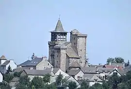 The village of Sainte-Radegonde, with the fortified church | |
 Coat of arms | |
Location of Sainte-Radegonde | |
 Sainte-Radegonde  Sainte-Radegonde | |
| Coordinates: 44°20′12″N 2°37′38″E / 44.336751°N 2.627141°E | |
| Country | France |
| Region | Occitania |
| Department | Aveyron |
| Arrondissement | Rodez |
| Canton | Nord-Lévezou |
| Intercommunality | Rodez Agglomération |
| Government | |
| • Mayor (2020–2026) | Laurence Pagès-Touzé[1] |
| Area 1 | 30.48 km2 (11.77 sq mi) |
| Population | 1,755 |
| • Density | 58/km2 (150/sq mi) |
| Time zone | UTC+01:00 (CET) |
| • Summer (DST) | UTC+02:00 (CEST) |
| INSEE/Postal code | 12241 /12850 |
| Elevation | 526–791 m (1,726–2,595 ft) (avg. 535 m or 1,755 ft) |
| 1 French Land Register data, which excludes lakes, ponds, glaciers > 1 km2 (0.386 sq mi or 247 acres) and river estuaries. | |
Sainte-Radegonde (French pronunciation: [sɛ̃t ʁadɡɔ̃d]; Languedocien: Senta Radegonda) is a commune in the Aveyron department in Occitania in southern France.
Population
| Year | Pop. | ±% |
|---|---|---|
| 1962 | 489 | — |
| 1968 | 452 | −7.6% |
| 1975 | 563 | +24.6% |
| 1982 | 1,027 | +82.4% |
| 1990 | 1,226 | +19.4% |
| 1999 | 1,355 | +10.5% |
| 2008 | 1,587 | +17.1% |
See also
References
- ↑ "Répertoire national des élus: les maires" (in French). data.gouv.fr, Plateforme ouverte des données publiques françaises. 13 September 2022.
- ↑ "Populations légales 2021". The National Institute of Statistics and Economic Studies. 28 December 2023.
Wikimedia Commons has media related to Sainte-Radegonde, Aveyron.
This article is issued from Wikipedia. The text is licensed under Creative Commons - Attribution - Sharealike. Additional terms may apply for the media files.