Gronard | |
|---|---|
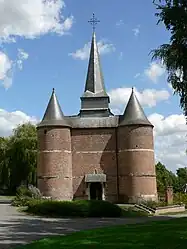 The church of Gronard | |
Location of Gronard | |
 Gronard  Gronard | |
| Coordinates: 49°47′38″N 3°53′05″E / 49.7939°N 3.8847°E | |
| Country | France |
| Region | Hauts-de-France |
| Department | Aisne |
| Arrondissement | Vervins |
| Canton | Vervins |
| Intercommunality | Thiérache du Centre |
| Government | |
| • Mayor (2020–2026) | Alexis De Wever[1] |
| Area 1 | 7.1 km2 (2.7 sq mi) |
| Population | 66 |
| • Density | 9.3/km2 (24/sq mi) |
| Time zone | UTC+01:00 (CET) |
| • Summer (DST) | UTC+02:00 (CEST) |
| INSEE/Postal code | 02357 /02140 |
| Elevation | 100–190 m (330–620 ft) (avg. 138 m or 453 ft) |
| 1 French Land Register data, which excludes lakes, ponds, glaciers > 1 km2 (0.386 sq mi or 247 acres) and river estuaries. | |
Gronard (French pronunciation: [ɡʁɔnaʁ]) is a commune in the Aisne department in Hauts-de-France in northern France. Its 16th century fortified church is a classified monument historique.[3]
Population
| Year | Pop. | ±% p.a. |
|---|---|---|
| 1968 | 108 | — |
| 1975 | 85 | −3.36% |
| 1982 | 85 | +0.00% |
| 1990 | 79 | −0.91% |
| 1999 | 78 | −0.14% |
| 2009 | 72 | −0.80% |
| 2014 | 77 | +1.35% |
| 2020 | 70 | −1.58% |
| Source: INSEE[4] | ||
See also
References
- ↑ "Répertoire national des élus: les maires". data.gouv.fr, Plateforme ouverte des données publiques françaises (in French). 9 August 2021.
- ↑ "Populations légales 2021". The National Institute of Statistics and Economic Studies. 28 December 2023.
- ↑ Base Mérimée: PA00115691, Ministère français de la Culture. (in French)
- ↑ Population en historique depuis 1968, INSEE
Wikimedia Commons has media related to Gronard.
This article is issued from Wikipedia. The text is licensed under Creative Commons - Attribution - Sharealike. Additional terms may apply for the media files.