Bonlieu-sur-Roubion | |
|---|---|
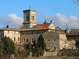 The abbey of Saint-Anne in Bonlieu-sur-Roubion | |
 Coat of arms | |
Location of Bonlieu-sur-Roubion | |
 Bonlieu-sur-Roubion  Bonlieu-sur-Roubion | |
| Coordinates: 44°35′43″N 4°52′56″E / 44.5953°N 4.8822°E | |
| Country | France |
| Region | Auvergne-Rhône-Alpes |
| Department | Drôme |
| Arrondissement | Nyons |
| Canton | Dieulefit |
| Intercommunality | Montélimar Agglomération |
| Government | |
| • Mayor (2020–2026) | Allain Dorlhiac[1] |
| Area 1 | 6.05 km2 (2.34 sq mi) |
| Population | 464 |
| • Density | 77/km2 (200/sq mi) |
| Time zone | UTC+01:00 (CET) |
| • Summer (DST) | UTC+02:00 (CEST) |
| INSEE/Postal code | 26052 /26160 |
| Elevation | 130–212 m (427–696 ft) |
| 1 French Land Register data, which excludes lakes, ponds, glaciers > 1 km2 (0.386 sq mi or 247 acres) and river estuaries. | |
Bonlieu-sur-Roubion (French pronunciation: [bɔ̃ljø syʁ ʁubjɔ̃]) is a commune in the Drôme department in southeastern France.
Population
| Year | Pop. | ±% p.a. |
|---|---|---|
| 1968 | 170 | — |
| 1975 | 144 | −2.34% |
| 1982 | 221 | +6.31% |
| 1990 | 286 | +3.28% |
| 1999 | 378 | +3.15% |
| 2009 | 376 | −0.05% |
| 2014 | 429 | +2.67% |
| 2020 | 473 | +1.64% |
| Source: INSEE[3] | ||
See also
References
- ↑ "Répertoire national des élus: les maires" (in French). data.gouv.fr, Plateforme ouverte des données publiques françaises. 13 September 2022.
- ↑ "Populations légales 2021". The National Institute of Statistics and Economic Studies. 28 December 2023.
- ↑ Population en historique depuis 1968, INSEE
Wikimedia Commons has media related to Bonlieu-sur-Roubion.
This article is issued from Wikipedia. The text is licensed under Creative Commons - Attribution - Sharealike. Additional terms may apply for the media files.