Romeyer | |
|---|---|
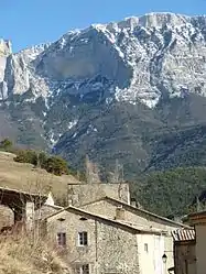 The village of Romeyer | |
Location of Romeyer | |
 Romeyer  Romeyer | |
| Coordinates: 44°46′49″N 5°24′34″E / 44.7803°N 5.4094°E | |
| Country | France |
| Region | Auvergne-Rhône-Alpes |
| Department | Drôme |
| Arrondissement | Die |
| Canton | Le Diois |
| Intercommunality | Diois |
| Government | |
| • Mayor (2020–2026) | Anne-Line Guironnet[1] |
| Area 1 | 41.46 km2 (16.01 sq mi) |
| Population | 216 |
| • Density | 5.2/km2 (13/sq mi) |
| Time zone | UTC+01:00 (CET) |
| • Summer (DST) | UTC+02:00 (CEST) |
| INSEE/Postal code | 26282 /26150 |
| Elevation | 478–2,000 m (1,568–6,562 ft) (avg. 530 m or 1,740 ft) |
| 1 French Land Register data, which excludes lakes, ponds, glaciers > 1 km2 (0.386 sq mi or 247 acres) and river estuaries. | |
Romeyer (French pronunciation: [ʁɔmɛje]; Occitan: Romeièr) is a commune in the Drôme department in southeastern France.
Population
| Year | Pop. | ±% p.a. |
|---|---|---|
| 1968 | 150 | — |
| 1975 | 129 | −2.13% |
| 1982 | 113 | −1.87% |
| 1990 | 114 | +0.11% |
| 1999 | 154 | +3.40% |
| 2009 | 214 | +3.34% |
| 2014 | 208 | −0.57% |
| 2020 | 202 | −0.49% |
| Source: INSEE[3] | ||
See also
References
- ↑ "Répertoire national des élus: les maires". data.gouv.fr, Plateforme ouverte des données publiques françaises (in French). 9 August 2021.
- ↑ "Populations légales 2021". The National Institute of Statistics and Economic Studies. 28 December 2023.
- ↑ Population en historique depuis 1968, INSEE
Wikimedia Commons has media related to Romeyer.
This article is issued from Wikipedia. The text is licensed under Creative Commons - Attribution - Sharealike. Additional terms may apply for the media files.