Castéra-Verduzan | |
|---|---|
.svg.png.webp) Coat of arms | |
Location of Castéra-Verduzan | |
 Castéra-Verduzan  Castéra-Verduzan | |
| Coordinates: 43°48′19″N 0°25′53″E / 43.8053°N 0.4314°E | |
| Country | France |
| Region | Occitania |
| Department | Gers |
| Arrondissement | Auch |
| Canton | Baïse-Armagnac |
| Intercommunality | CA Grand Auch Cœur Gascogne |
| Government | |
| • Mayor (2020–2026) | Claude Nef[1] |
| Area 1 | 19.82 km2 (7.65 sq mi) |
| Population | 1,039 |
| • Density | 52/km2 (140/sq mi) |
| Time zone | UTC+01:00 (CET) |
| • Summer (DST) | UTC+02:00 (CEST) |
| INSEE/Postal code | 32083 /32410 |
| Elevation | 97–221 m (318–725 ft) (avg. 119 m or 390 ft) |
| 1 French Land Register data, which excludes lakes, ponds, glaciers > 1 km2 (0.386 sq mi or 247 acres) and river estuaries. | |
Castéra-Verduzan (French pronunciation: [kasteʁa vɛʁdyzɑ̃]; Occitan: Lo Casterar e Verdusan) is a commune in the Gers department in southwestern France.
Geography
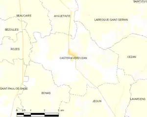
Castéra-Verduzan and its surrounding communes
Population
| Year | Pop. | ±% |
|---|---|---|
| 1962 | 682 | — |
| 1968 | 738 | +8.2% |
| 1975 | 719 | −2.6% |
| 1982 | 753 | +4.7% |
| 1990 | 794 | +5.4% |
| 1999 | 830 | +4.5% |
| 2008 | 925 | +11.4% |
See also
References
- ↑ "Répertoire national des élus: les maires". data.gouv.fr, Plateforme ouverte des données publiques françaises (in French). 9 August 2021.
- ↑ "Populations légales 2021". The National Institute of Statistics and Economic Studies. 28 December 2023.
Wikimedia Commons has media related to Castéra-Verduzan.
This article is issued from Wikipedia. The text is licensed under Creative Commons - Attribution - Sharealike. Additional terms may apply for the media files.