Saint-Avit-Frandat | |
|---|---|
.jpg.webp) The town hall in Saint-Avit-Frandat | |
Location of Saint-Avit-Frandat | |
 Saint-Avit-Frandat  Saint-Avit-Frandat | |
| Coordinates: 43°58′43″N 0°39′10″E / 43.9786°N 0.6528°E | |
| Country | France |
| Region | Occitania |
| Department | Gers |
| Arrondissement | Condom |
| Canton | Lectoure-Lomagne |
| Government | |
| • Mayor (2020–2026) | Serge Pivetta[1] |
| Area 1 | 7.55 km2 (2.92 sq mi) |
| Population | 97 |
| • Density | 13/km2 (33/sq mi) |
| Time zone | UTC+01:00 (CET) |
| • Summer (DST) | UTC+02:00 (CEST) |
| INSEE/Postal code | 32364 /32700 |
| Elevation | 96–195 m (315–640 ft) (avg. 180 m or 590 ft) |
| 1 French Land Register data, which excludes lakes, ponds, glaciers > 1 km2 (0.386 sq mi or 247 acres) and river estuaries. | |
Saint-Avit-Frandat (French pronunciation: [sɛ̃.t‿avi fʁɑ̃da]; Gascon: Sent Avit e Frandat) is a commune in the Gers department in southwestern France.
Geography
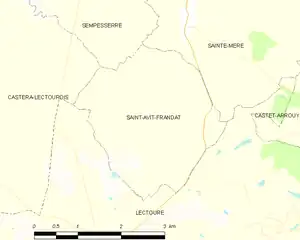
Saint-Avit-Frandat and its surrounding communes
Population
| Year | Pop. | ±% |
|---|---|---|
| 1962 | 136 | — |
| 1968 | 126 | −7.4% |
| 1975 | 119 | −5.6% |
| 1982 | 113 | −5.0% |
| 1990 | 92 | −18.6% |
| 1999 | 85 | −7.6% |
| 2008 | 106 | +24.7% |
See also
References
- ↑ "Répertoire national des élus: les maires". data.gouv.fr, Plateforme ouverte des données publiques françaises (in French). 2 December 2020.
- ↑ "Populations légales 2021". The National Institute of Statistics and Economic Studies. 28 December 2023.
Wikimedia Commons has media related to Saint-Avit-Frandat.
This article is issued from Wikipedia. The text is licensed under Creative Commons - Attribution - Sharealike. Additional terms may apply for the media files.