Sainte-Dode | |
|---|---|
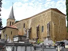 The church in Sainte-Dode | |
Location of Sainte-Dode | |
 Sainte-Dode  Sainte-Dode | |
| Coordinates: 43°25′16″N 0°21′51″E / 43.4211°N 0.3642°E | |
| Country | France |
| Region | Occitania |
| Department | Gers |
| Arrondissement | Mirande |
| Canton | Mirande-Astarac |
| Government | |
| • Mayor (2020–2026) | Hervé Tujague[1] |
| Area 1 | 18.84 km2 (7.27 sq mi) |
| Population | 219 |
| • Density | 12/km2 (30/sq mi) |
| Time zone | UTC+01:00 (CET) |
| • Summer (DST) | UTC+02:00 (CEST) |
| INSEE/Postal code | 32373 /32170 |
| Elevation | 179–340 m (587–1,115 ft) (avg. 268 m or 879 ft) |
| 1 French Land Register data, which excludes lakes, ponds, glaciers > 1 km2 (0.386 sq mi or 247 acres) and river estuaries. | |
Sainte-Dode (French pronunciation: [sɛ̃t dɔd]; Gascon: Senta Dora) is a commune in the Gers department in southwestern France.
Geography
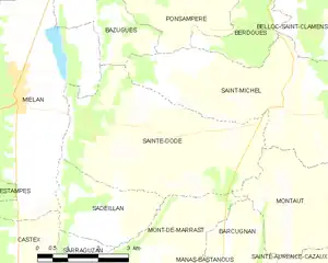
Sainte-Dode and its surrounding communes
Population
| Year | Pop. | ±% |
|---|---|---|
| 1962 | 354 | — |
| 1968 | 322 | −9.0% |
| 1975 | 285 | −11.5% |
| 1982 | 260 | −8.8% |
| 1990 | 264 | +1.5% |
| 1999 | 238 | −9.8% |
| 2008 | 223 | −6.3% |
See also
References
- ↑ "Répertoire national des élus: les maires". data.gouv.fr, Plateforme ouverte des données publiques françaises (in French). 9 August 2021.
- ↑ "Populations légales 2021". The National Institute of Statistics and Economic Studies. 28 December 2023.
Wikimedia Commons has media related to Sainte-Dode.
This article is issued from Wikipedia. The text is licensed under Creative Commons - Attribution - Sharealike. Additional terms may apply for the media files.