Sainte-Christie | |
|---|---|
.svg.png.webp) Coat of arms | |
Location of Sainte-Christie | |
 Sainte-Christie  Sainte-Christie | |
| Coordinates: 43°45′21″N 0°38′02″E / 43.7558°N 0.6339°E | |
| Country | France |
| Region | Occitania |
| Department | Gers |
| Arrondissement | Auch |
| Canton | Gascogne-Auscitaine |
| Intercommunality | CA Grand Auch Cœur Gascogne |
| Government | |
| • Mayor (2020–2026) | Pierre Cahuzac[1] |
| Area 1 | 9.91 km2 (3.83 sq mi) |
| Population | 539 |
| • Density | 54/km2 (140/sq mi) |
| Time zone | UTC+01:00 (CET) |
| • Summer (DST) | UTC+02:00 (CEST) |
| INSEE/Postal code | 32368 /32390 |
| Elevation | 100–178 m (328–584 ft) |
| 1 French Land Register data, which excludes lakes, ponds, glaciers > 1 km2 (0.386 sq mi or 247 acres) and river estuaries. | |
Sainte-Christie (French pronunciation: [sɛ̃t kʁisti]; Occitan: Senta Crestia) is a commune in the Gers department in southwestern France.
Geography
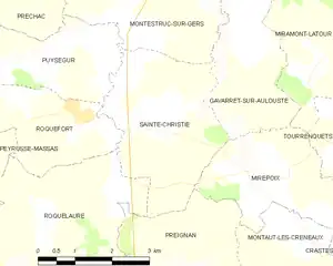
Saint-Christie and its surrounding communes
Population
| Year | Pop. | ±% |
|---|---|---|
| 1962 | 393 | — |
| 1968 | 356 | −9.4% |
| 1975 | 345 | −3.1% |
| 1982 | 325 | −5.8% |
| 1990 | 389 | +19.7% |
| 1999 | 418 | +7.5% |
| 2008 | 539 | +28.9% |
See also
References
- ↑ "Répertoire national des élus: les maires" (in French). data.gouv.fr, Plateforme ouverte des données publiques françaises. 13 September 2022.
- ↑ "Populations légales 2021". The National Institute of Statistics and Economic Studies. 28 December 2023.
Wikimedia Commons has media related to Sainte-Christie.
This article is issued from Wikipedia. The text is licensed under Creative Commons - Attribution - Sharealike. Additional terms may apply for the media files.