Lasserrade | |
|---|---|
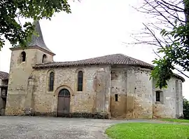 The church in Lasserrade | |
Location of Lasserrade | |
 Lasserrade  Lasserrade | |
| Coordinates: 43°37′33″N 0°03′51″E / 43.6258°N 0.0642°E | |
| Country | France |
| Region | Occitania |
| Department | Gers |
| Arrondissement | Mirande |
| Canton | Pardiac-Rivière-Basse |
| Government | |
| • Mayor (2020–2026) | Isabelle Blanchard[1] |
| Area 1 | 12.76 km2 (4.93 sq mi) |
| Population | 184 |
| • Density | 14/km2 (37/sq mi) |
| Time zone | UTC+01:00 (CET) |
| • Summer (DST) | UTC+02:00 (CEST) |
| INSEE/Postal code | 32199 /32160 |
| Elevation | 120–204 m (394–669 ft) (avg. 180 m or 590 ft) |
| 1 French Land Register data, which excludes lakes, ponds, glaciers > 1 km2 (0.386 sq mi or 247 acres) and river estuaries. | |
Lasserrade (before 2020: Lasserade)[3] is a commune in the Gers department in southwestern France.
Geography
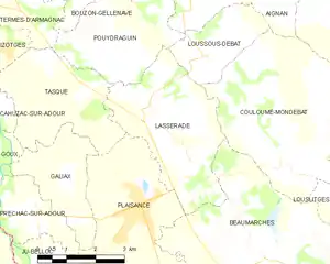
Lasserrade and its surrounding communes
Population
| Year | Pop. | ±% |
|---|---|---|
| 1962 | 308 | — |
| 1968 | 295 | −4.2% |
| 1975 | 268 | −9.2% |
| 1982 | 251 | −6.3% |
| 1990 | 211 | −15.9% |
| 1999 | 226 | +7.1% |
| 2008 | 202 | −10.6% |
See also
References
- ↑ "Répertoire national des élus: les maires". data.gouv.fr, Plateforme ouverte des données publiques françaises (in French). 9 August 2021.
- ↑ "Populations légales 2021". The National Institute of Statistics and Economic Studies. 28 December 2023.
- ↑ Décret n° 2020-175 26 February 2020 (in French)
Wikimedia Commons has media related to Lasserrade.
This article is issued from Wikipedia. The text is licensed under Creative Commons - Attribution - Sharealike. Additional terms may apply for the media files.