Monferran-Plavès | |
|---|---|
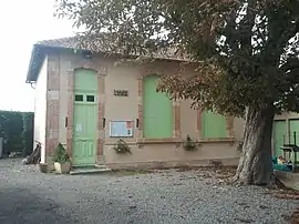 The town hall in Monferran-Plavès | |
Location of Monferran-Plavès | |
 Monferran-Plavès  Monferran-Plavès | |
| Coordinates: 43°29′35″N 0°38′24″E / 43.4931°N 0.64°E | |
| Country | France |
| Region | Occitania |
| Department | Gers |
| Arrondissement | Mirande |
| Canton | Astarac-Gimone |
| Intercommunality | Val de Gers |
| Government | |
| • Mayor (2020–2026) | Pierre Michelin[1] |
| Area 1 | 11.07 km2 (4.27 sq mi) |
| Population | 109 |
| • Density | 9.8/km2 (26/sq mi) |
| Time zone | UTC+01:00 (CET) |
| • Summer (DST) | UTC+02:00 (CEST) |
| INSEE/Postal code | 32267 /32260 |
| Elevation | 190–294 m (623–965 ft) (avg. 300 m or 980 ft) |
| 1 French Land Register data, which excludes lakes, ponds, glaciers > 1 km2 (0.386 sq mi or 247 acres) and river estuaries. | |
Monferran-Plavès (French pronunciation: [mɔ̃fɛ̃ʁɑ̃ plavɛs]; Occitan: Montferrand e Plavés) is a commune in the Gers department in southwestern France.
Geography
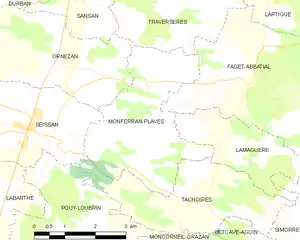
Monferran-Plavès and its surrounding communes
Population
| Year | Pop. | ±% |
|---|---|---|
| 1962 | 104 | — |
| 1968 | 131 | +26.0% |
| 1975 | 110 | −16.0% |
| 1982 | 111 | +0.9% |
| 1990 | 119 | +7.2% |
| 1999 | 111 | −6.7% |
| 2008 | 126 | +13.5% |
See also
References
- ↑ "Répertoire national des élus: les maires" (in French). data.gouv.fr, Plateforme ouverte des données publiques françaises. 13 September 2022.
- ↑ "Populations légales 2021". The National Institute of Statistics and Economic Studies. 28 December 2023.
Wikimedia Commons has media related to Monferran-Plavès.
This article is issued from Wikipedia. The text is licensed under Creative Commons - Attribution - Sharealike. Additional terms may apply for the media files.