Cires-lès-Mello | |
|---|---|
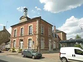 The town hall in Cires-lès-Mello | |
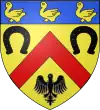 Coat of arms | |
Location of Cires-lès-Mello | |
 Cires-lès-Mello  Cires-lès-Mello | |
| Coordinates: 49°16′26″N 2°21′27″E / 49.2739°N 2.3575°E | |
| Country | France |
| Region | Hauts-de-France |
| Department | Oise |
| Arrondissement | Senlis |
| Canton | Montataire |
| Government | |
| • Mayor (2020–2026) | Alain Guerinet[1] |
| Area 1 | 16.73 km2 (6.46 sq mi) |
| Population | 3,989 |
| • Density | 240/km2 (620/sq mi) |
| Time zone | UTC+01:00 (CET) |
| • Summer (DST) | UTC+02:00 (CEST) |
| INSEE/Postal code | 60155 /60660 |
| Elevation | 32–149 m (105–489 ft) (avg. 37 m or 121 ft) |
| 1 French Land Register data, which excludes lakes, ponds, glaciers > 1 km2 (0.386 sq mi or 247 acres) and river estuaries. | |
Cires-lès-Mello (French pronunciation: [siʁ lɛ mɛlo], literally Cires near Mello) is a commune in the Oise department in northern France. Cires-lès-Mello station has rail connections to Beauvais and Creil.
Population
| Year | Pop. | ±% p.a. |
|---|---|---|
| 1968 | 1,490 | — |
| 1975 | 1,884 | +3.41% |
| 1982 | 2,992 | +6.83% |
| 1990 | 3,458 | +1.83% |
| 1999 | 3,585 | +0.40% |
| 2007 | 3,482 | −0.36% |
| 2012 | 3,696 | +1.20% |
| 2017 | 3,977 | +1.48% |
| Source: INSEE[3] | ||
See also
References
- ↑ "Répertoire national des élus: les maires" (in French). data.gouv.fr, Plateforme ouverte des données publiques françaises. 13 September 2022.
- ↑ "Populations légales 2021". The National Institute of Statistics and Economic Studies. 28 December 2023.
- ↑ Population en historique depuis 1968, INSEE
Wikimedia Commons has media related to Cires-lès-Mello.
This article is issued from Wikipedia. The text is licensed under Creative Commons - Attribution - Sharealike. Additional terms may apply for the media files.