| Gresvatnet (Norwegian) Gräsvattnet (Swedish) Graesiejaevrie (Southern Sami) | |
|---|---|
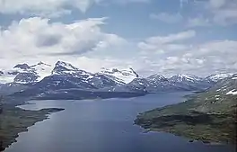 Grasvatnet and Oksskolten mountains in the background | |
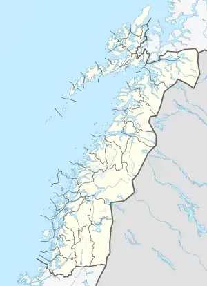 Gresvatet Location of the lake in Nordland  Gresvatet Gresvatet (Norway) | |
| Location | Nordland, Norway and Västerbotten, Sweden |
| Coordinates | 66°03′28″N 14°27′32″E / 66.0579°N 14.4589°E |
| Basin countries | Norway and Sweden |
| Max. length | 11 kilometres (6.8 mi) |
| Max. width | 4.5 kilometres (2.8 mi) |
| Surface area | 22.63 km2 (8.74 sq mi) (18.67 km2 or 7.21 sq mi in Norway) |
| Shore length1 | 44 kilometres (27 mi) |
| Surface elevation | 595 metres (1,952 ft) |
| References | NVE |
| 1 Shore length is not a well-defined measure. | |
Gresvatnet (Norwegian) or Gräsvattnet (Swedish) or Graesiejaevrie (Southern Sami) is a lake on the border between Norway and Sweden. Most of the lake lies in Hemnes Municipality in Nordland county (Norway) and then a small portion crosses the border into Storuman Municipality in Västerbotten County (Sweden). The lake lies about 25 kilometres (16 mi) east of the village of Korgen, and just a few kilometres northeast of the mountain Oksskolten and the Okstindbreen glacier. The lake is one of the upper reservoirs for the Bjerka Hydroelectric Power Station.[1]
See also
References
- ↑ Thorsnæs, Geir, ed. (2016-03-28). "Gresvatnet". Store norske leksikon (in Norwegian). Kunnskapsforlaget. Retrieved 2019-02-16.
This article is issued from Wikipedia. The text is licensed under Creative Commons - Attribution - Sharealike. Additional terms may apply for the media files.