Chantesse | |
|---|---|
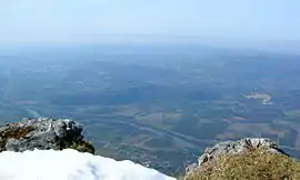 General view from the Cheminée (Vercors) of Vinay, l'Albenc, Chantesse and Poliénas with Isère at the top, and La Rivière below. | |
Location of Chantesse | |
 Chantesse  Chantesse | |
| Coordinates: 45°14′37″N 5°26′42″E / 45.2436°N 5.445°E | |
| Country | France |
| Region | Auvergne-Rhône-Alpes |
| Department | Isère |
| Arrondissement | Grenoble |
| Canton | Le Sud Grésivaudan |
| Intercommunality | Saint-Marcellin Vercors Isère |
| Government | |
| • Mayor (2020–2026) | Isabelle Oriol[1] |
| Area 1 | 5.83 km2 (2.25 sq mi) |
| Population | 386 |
| • Density | 66/km2 (170/sq mi) |
| Time zone | UTC+01:00 (CET) |
| • Summer (DST) | UTC+02:00 (CEST) |
| INSEE/Postal code | 38074 /38470 |
| Elevation | 247–489 m (810–1,604 ft) |
| 1 French Land Register data, which excludes lakes, ponds, glaciers > 1 km2 (0.386 sq mi or 247 acres) and river estuaries. | |
Chantesse (French pronunciation: [ʃɑ̃tɛs]) is a commune in the Isère department in southeastern France.
Population
| Year | Pop. | ±% p.a. |
|---|---|---|
| 1968 | 140 | — |
| 1975 | 150 | +0.99% |
| 1982 | 213 | +5.14% |
| 1990 | 262 | +2.62% |
| 1999 | 269 | +0.29% |
| 2007 | 293 | +1.07% |
| 2012 | 320 | +1.78% |
| 2017 | 337 | +1.04% |
| Source: INSEE[3] | ||
See also
References
- ↑ "Répertoire national des élus: les maires". data.gouv.fr, Plateforme ouverte des données publiques françaises (in French). 2 December 2020.
- ↑ "Populations légales 2021". The National Institute of Statistics and Economic Studies. 28 December 2023.
- ↑ Population en historique depuis 1968, INSEE
Wikimedia Commons has media related to Chantesse.
This article is issued from Wikipedia. The text is licensed under Creative Commons - Attribution - Sharealike. Additional terms may apply for the media files.