Corrençon-en-Vercors | |
|---|---|
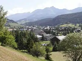 A general view of Corrençon | |
Location of Corrençon-en-Vercors | |
 Corrençon-en-Vercors  Corrençon-en-Vercors | |
| Coordinates: 45°01′56″N 5°31′37″E / 45.0322°N 5.5269°E | |
| Country | France |
| Region | Auvergne-Rhône-Alpes |
| Department | Isère |
| Arrondissement | Grenoble |
| Canton | Fontaine-Vercors |
| Intercommunality | Massif du Vercors |
| Government | |
| • Mayor (2020–2026) | Thomas Guillet[1] |
| Area 1 | 39 km2 (15 sq mi) |
| Population | 366 |
| • Density | 9.4/km2 (24/sq mi) |
| Time zone | UTC+01:00 (CET) |
| • Summer (DST) | UTC+02:00 (CEST) |
| INSEE/Postal code | 38129 /38250 |
| Elevation | 1,055–2,286 m (3,461–7,500 ft) |
| 1 French Land Register data, which excludes lakes, ponds, glaciers > 1 km2 (0.386 sq mi or 247 acres) and river estuaries. | |
Corrençon-en-Vercors (French pronunciation: [kɔʁɑ̃sɔ̃ ɑ̃ vɛʁkɔʁ], literally Corrençon in Vercors) is a commune in the Isère department in southeastern France.
Population
| Year | Pop. | ±% p.a. |
|---|---|---|
| 1968 | 159 | — |
| 1975 | 193 | +2.81% |
| 1982 | 259 | +4.29% |
| 1990 | 264 | +0.24% |
| 1999 | 322 | +2.23% |
| 2007 | 364 | +1.54% |
| 2012 | 358 | −0.33% |
| 2017 | 354 | −0.22% |
| Source: INSEE[3] | ||
See also
References
- ↑ "Répertoire national des élus: les maires". data.gouv.fr, Plateforme ouverte des données publiques françaises (in French). 2 December 2020.
- ↑ "Populations légales 2021". The National Institute of Statistics and Economic Studies. 28 December 2023.
- ↑ Population en historique depuis 1968, INSEE
External links
Wikimedia Commons has media related to Corrençon-en-Vercors.
This article is issued from Wikipedia. The text is licensed under Creative Commons - Attribution - Sharealike. Additional terms may apply for the media files.