Cardonnette | |
|---|---|
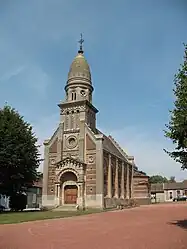 The church in Cardonnette | |
.svg.png.webp) Coat of arms | |
Location of Cardonnette | |
 Cardonnette  Cardonnette | |
| Coordinates: 49°57′07″N 2°21′36″E / 49.9519°N 2.36°E | |
| Country | France |
| Region | Hauts-de-France |
| Department | Somme |
| Arrondissement | Amiens |
| Canton | Amiens-2 |
| Intercommunality | CA Amiens Métropole |
| Government | |
| • Mayor (2020–2026) | Hubert Taufour[1] |
| Area 1 | 5.46 km2 (2.11 sq mi) |
| Population | 522 |
| • Density | 96/km2 (250/sq mi) |
| Time zone | UTC+01:00 (CET) |
| • Summer (DST) | UTC+02:00 (CEST) |
| INSEE/Postal code | 80173 /80260 |
| Elevation | 56–117 m (184–384 ft) (avg. 80 m or 260 ft) |
| 1 French Land Register data, which excludes lakes, ponds, glaciers > 1 km2 (0.386 sq mi or 247 acres) and river estuaries. | |
Cardonnette (French pronunciation: [kaʁdɔnɛt]) is a commune in the Somme department in Hauts-de-France in northern France.
Geography
Cardonette is situated on the D11 and D247 crossroads, just 5 miles (8 km) northwest of Amiens.
Population
| Year | Pop. | ±% p.a. |
|---|---|---|
| 1968 | 213 | — |
| 1975 | 275 | +3.72% |
| 1982 | 408 | +5.80% |
| 1990 | 458 | +1.46% |
| 1999 | 417 | −1.04% |
| 2007 | 427 | +0.30% |
| 2012 | 465 | +1.72% |
| 2017 | 518 | +2.18% |
| Source: INSEE[3] | ||
Points of interest
- The church, rebuilt after World War I.
See also
References
- ↑ "Répertoire national des élus: les maires". data.gouv.fr, Plateforme ouverte des données publiques françaises (in French). 2 December 2020.
- ↑ "Populations légales 2021". The National Institute of Statistics and Economic Studies. 28 December 2023.
- ↑ Population en historique depuis 1968, INSEE
External links
Wikimedia Commons has media related to Cardonnette.
- Official website (in French)
This article is issued from Wikipedia. The text is licensed under Creative Commons - Attribution - Sharealike. Additional terms may apply for the media files.