Ambrines | |
|---|---|
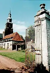 The church of Ambrines | |
 Coat of arms | |
Location of Ambrines | |
 Ambrines  Ambrines | |
| Coordinates: 50°18′41″N 2°28′10″E / 50.3114°N 2.4694°E | |
| Country | France |
| Region | Hauts-de-France |
| Department | Pas-de-Calais |
| Arrondissement | Arras |
| Canton | Avesnes-le-Comte |
| Intercommunality | Campagnes de l'Artois |
| Government | |
| • Mayor (2020–2026) | Alain Rose[1] |
| Area 1 | 4.68 km2 (1.81 sq mi) |
| Population | 212 |
| • Density | 45/km2 (120/sq mi) |
| Time zone | UTC+01:00 (CET) |
| • Summer (DST) | UTC+02:00 (CEST) |
| INSEE/Postal code | 62027 /62127 |
| Elevation | 107–139 m (351–456 ft) (avg. 127 m or 417 ft) |
| 1 French Land Register data, which excludes lakes, ponds, glaciers > 1 km2 (0.386 sq mi or 247 acres) and river estuaries. | |
Ambrines (French pronunciation: [ɑ̃bʁin]; Picard: Ambrainne) is a commune in the Pas-de-Calais department in northern France.[3]
Geography
A farming village located 12miles (19 km) west of Arras, at the D8 and D54 road junction.
Population
| Year | Pop. | ±% |
|---|---|---|
| 1962 | 177 | — |
| 1968 | 196 | +10.7% |
| 1975 | 191 | −2.6% |
| 1982 | 167 | −12.6% |
| 1990 | 169 | +1.2% |
| 1999 | 169 | +0.0% |
| 2006 | 202 | +19.5% |
| 2007 | 207 | +2.5% |
| 2008 | 211 | +1.9% |
| 2009 | 216 | +2.4% |
| 2013 | 254 | +17.6% |
| 2014 | 260 | +2.4% |
| 2015 | 265 | +1.9% |
| 2020 | 217 | −18.1% |
Sights
- The church of St.Leger, dating from the eighteenth century.
- A nineteenth-century chateau.
See also
References
- ↑ "Répertoire national des élus: les maires". data.gouv.fr, Plateforme ouverte des données publiques françaises (in French). 2 December 2020.
- ↑ "Populations légales 2021". The National Institute of Statistics and Economic Studies. 28 December 2023.
- ↑ INSEE commune file
Wikimedia Commons has media related to Ambrines.
This article is issued from Wikipedia. The text is licensed under Creative Commons - Attribution - Sharealike. Additional terms may apply for the media files.