Beaudricourt | |
|---|---|
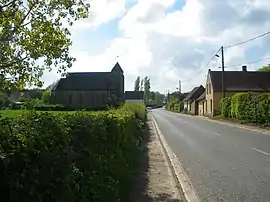 A general view of Beaudricourt | |
 Coat of arms | |
Location of Beaudricourt | |
 Beaudricourt  Beaudricourt | |
| Coordinates: 50°14′55″N 2°24′32″E / 50.2486°N 2.4089°E / 50.2486; 2.4089 | |
| Country | France |
| Region | Hauts-de-France |
| Department | Pas-de-Calais |
| Arrondissement | Arras |
| Canton | Avesnes-le-Comte |
| Intercommunality | CC Campagnes de l'Artois |
| Government | |
| • Mayor (2020–2026) | Béatrice Dausse[1] |
| Area 1 | 4.58 km2 (1.77 sq mi) |
| Population | 94 |
| • Density | 21/km2 (53/sq mi) |
| Time zone | UTC+01:00 (CET) |
| • Summer (DST) | UTC+02:00 (CEST) |
| INSEE/Postal code | 62091 /62810 |
| Elevation | 104–159 m (341–522 ft) (avg. 143 m or 469 ft) |
| 1 French Land Register data, which excludes lakes, ponds, glaciers > 1 km2 (0.386 sq mi or 247 acres) and river estuaries. | |
Beaudricourt (French pronunciation: [bodʁikuʁ]) is a commune in the Pas-de-Calais department in the Hauts-de-France region in northern France.[3]
Geography
A small farming village located 18 miles (28 km) west of Arras on the D23 road.
Population
| Year | Pop. | ±% |
|---|---|---|
| 1962 | 107 | — |
| 1968 | 124 | +15.9% |
| 1975 | 100 | −19.4% |
| 1982 | 97 | −3.0% |
| 1990 | 92 | −5.2% |
| 1999 | 92 | +0.0% |
| 2006 | 99 | +7.6% |
| 2009 | 98 | −1.0% |
| 2011 | 99 | +1.0% |
| 2015 | 94 | −5.1% |
Sights
- The church, dating from the nineteenth century.
See also
References
- ↑ "Répertoire national des élus: les maires". data.gouv.fr, Plateforme ouverte des données publiques françaises (in French). 2 December 2020.
- ↑ "Populations légales 2021". The National Institute of Statistics and Economic Studies. 28 December 2023.
- ↑ INSEE commune file
Wikimedia Commons has media related to Beaudricourt.
This article is issued from Wikipedia. The text is licensed under Creative Commons - Attribution - Sharealike. Additional terms may apply for the media files.