Tangry | |
|---|---|
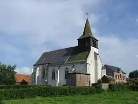 The church of Tangry | |
 Coat of arms | |
Location of Tangry | |
 Tangry  Tangry | |
| Coordinates: 50°27′57″N 2°21′18″E / 50.4658°N 2.355°E / 50.4658; 2.355 | |
| Country | France |
| Region | Hauts-de-France |
| Department | Pas-de-Calais |
| Arrondissement | Arras |
| Canton | Saint-Pol-sur-Ternoise |
| Intercommunality | CC Ternois |
| Government | |
| • Mayor (2020–2026) | Olivier Rigot[1] |
| Area 1 | 4.84 km2 (1.87 sq mi) |
| Population | 266 |
| • Density | 55/km2 (140/sq mi) |
| Time zone | UTC+01:00 (CET) |
| • Summer (DST) | UTC+02:00 (CEST) |
| INSEE/Postal code | 62805 /62550 |
| Elevation | 128–168 m (420–551 ft) (avg. 164 m or 538 ft) |
| 1 French Land Register data, which excludes lakes, ponds, glaciers > 1 km2 (0.386 sq mi or 247 acres) and river estuaries. | |
Tangry (French pronunciation: [tɑ̃ɡʁi]) is a commune in the Pas-de-Calais department in the Hauts-de-France region of France.[3]
Tangry lies 36 km northwest of Arras, at the junction of the D70, D77 and D99 roads.
Main sights
- The church of St.Omer, dating from the sixteenth century.
See also
References
- ↑ "Répertoire national des élus: les maires". data.gouv.fr, Plateforme ouverte des données publiques françaises (in French). 2 December 2020.
- ↑ "Populations légales 2021". The National Institute of Statistics and Economic Studies. 28 December 2023.
- ↑ INSEE commune file
Wikimedia Commons has media related to Tangry.
This article is issued from Wikipedia. The text is licensed under Creative Commons - Attribution - Sharealike. Additional terms may apply for the media files.