Vaudringhem
Woudringem | |
|---|---|
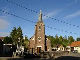 The church of Vaudringhem | |
 Coat of arms | |
Location of Vaudringhem | |
 Vaudringhem  Vaudringhem | |
| Coordinates: 50°39′45″N 2°01′45″E / 50.6625°N 2.0292°E | |
| Country | France |
| Region | Hauts-de-France |
| Department | Pas-de-Calais |
| Arrondissement | Saint-Omer |
| Canton | Lumbres |
| Intercommunality | Pays de Lumbres |
| Government | |
| • Mayor (2020–2026) | Olivier Merlo[1] |
| Area 1 | 7.61 km2 (2.94 sq mi) |
| Population | 497 |
| • Density | 65/km2 (170/sq mi) |
| Time zone | UTC+01:00 (CET) |
| • Summer (DST) | UTC+02:00 (CEST) |
| INSEE/Postal code | 62837 /62380 |
| Elevation | 94–200 m (308–656 ft) (avg. 150 m or 490 ft) |
| 1 French Land Register data, which excludes lakes, ponds, glaciers > 1 km2 (0.386 sq mi or 247 acres) and river estuaries. | |
Vaudringhem (Picard: Vaudringhin; West Flemish: Woudringem) is a commune in the Pas-de-Calais department in the Hauts-de-France region of France.[3]
Geography
Vaudringhem is located 14 miles (23 km) southwest of Saint-Omer, on the D203 road.
Population
| Year | Pop. | ±% p.a. |
|---|---|---|
| 1968 | 377 | — |
| 1975 | 390 | +0.49% |
| 1982 | 404 | +0.51% |
| 1990 | 391 | −0.41% |
| 1999 | 372 | −0.55% |
| 2007 | 457 | +2.61% |
| 2012 | 503 | +1.94% |
| 2017 | 532 | +1.13% |
| Source: INSEE[4] | ||
Places of interest
- The church of Saint Leger, dating from the eighteenth century.
See also
References
- ↑ "Répertoire national des élus: les maires" (in French). data.gouv.fr, Plateforme ouverte des données publiques françaises. 13 September 2022.
- ↑ "Populations légales 2021". The National Institute of Statistics and Economic Studies. 28 December 2023.
- ↑ INSEE commune file
- ↑ Population en historique depuis 1968, INSEE
Wikimedia Commons has media related to Vaudringhem.
This article is issued from Wikipedia. The text is licensed under Creative Commons - Attribution - Sharealike. Additional terms may apply for the media files.