Sapignies | |
|---|---|
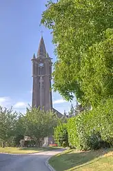 The church of Sapignies | |
 Coat of arms | |
Location of Sapignies | |
 Sapignies  Sapignies | |
| Coordinates: 50°08′05″N 2°50′09″E / 50.1347°N 2.8358°E | |
| Country | France |
| Region | Hauts-de-France |
| Department | Pas-de-Calais |
| Arrondissement | Arras |
| Canton | Bapaume |
| Intercommunality | CC Sud-Artois |
| Government | |
| • Mayor (2020–2026) | Anne-Sophie Delauttre[1] |
| Area 1 | 3.33 km2 (1.29 sq mi) |
| Population | 191 |
| • Density | 57/km2 (150/sq mi) |
| Time zone | UTC+01:00 (CET) |
| • Summer (DST) | UTC+02:00 (CEST) |
| INSEE/Postal code | 62776 /62121 |
| Elevation | 100–123 m (328–404 ft) (avg. 121 m or 397 ft) |
| 1 French Land Register data, which excludes lakes, ponds, glaciers > 1 km2 (0.386 sq mi or 247 acres) and river estuaries. | |
Sapignies (French pronunciation: [sapiɲi]) is a commune in the Pas-de-Calais department in the Hauts-de-France region of France.[3]
Geography
Sapignies lies 14 miles (23 km) south of Arras, at the junction of the D31E and N17 roads.
Population
| Year | Pop. | ±% p.a. |
|---|---|---|
| 1968 | 147 | — |
| 1975 | 140 | −0.69% |
| 1982 | 113 | −3.01% |
| 1990 | 137 | +2.44% |
| 1999 | 140 | +0.24% |
| 2007 | 196 | +4.30% |
| 2012 | 180 | −1.69% |
| 2017 | 196 | +1.72% |
| Source: INSEE[4] | ||
Places of interest
- The church of St.Pierre, rebuilt, along with most of the commune, after World War I.
- The German military cemetery.
See also
References
- ↑ "Répertoire national des élus: les maires". data.gouv.fr, Plateforme ouverte des données publiques françaises (in French). 9 August 2021.
- ↑ "Populations légales 2021". The National Institute of Statistics and Economic Studies. 28 December 2023.
- ↑ INSEE commune file
- ↑ Population en historique depuis 1968, INSEE
Wikimedia Commons has media related to Sapignies.
This article is issued from Wikipedia. The text is licensed under Creative Commons - Attribution - Sharealike. Additional terms may apply for the media files.