Bolozon | |
|---|---|
Commune | |
 | |
Location of Bolozon | |
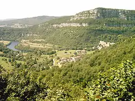
 Bolozon  Bolozon | |
| Coordinates: 46°11′34″N 5°28′22″E / 46.19290°N 5.47280°E | |
| Country | France |
| Region | Auvergne-Rhône-Alpes |
| Department | Ain |
| Arrondissement | Nantua |
| Canton | Pont-d'Ain |
| Intercommunality | Haut-Bugey Agglomération |
| Government | |
| • Mayor (2020–2026) | Etienne Girod[1] |
| Area 1 | 4.92 km2 (1.90 sq mi) |
| Population | 95 |
| • Density | 19/km2 (50/sq mi) |
| Time zone | UTC+01:00 (CET) |
| • Summer (DST) | UTC+02:00 (CEST) |
| INSEE/Postal code | 01051 /01450 |
| Elevation | 278–637 m (912–2,090 ft) (avg. 318 m or 1,043 ft) |
| 1 French Land Register data, which excludes lakes, ponds, glaciers > 1 km2 (0.386 sq mi or 247 acres) and river estuaries. | |
Bolozon (French pronunciation: [bɔlozɔ̃]) is a commune in the Ain department in eastern France. Cize—Bolozon station has rail connections to Bourg-en-Bresse and Oyonnax.
Population
| Year | Pop. | ±% p.a. |
|---|---|---|
| 1968 | 112 | — |
| 1975 | 84 | −4.03% |
| 1982 | 94 | +1.62% |
| 1990 | 93 | −0.13% |
| 1999 | 94 | +0.12% |
| 2007 | 100 | +0.78% |
| 2012 | 91 | −1.87% |
| 2017 | 89 | −0.44% |
| Source: INSEE[3] | ||
See also
References
- ↑ "Répertoire national des élus: les maires" (in French). data.gouv.fr, Plateforme ouverte des données publiques françaises. 13 September 2022.
- ↑ "Populations légales 2021". The National Institute of Statistics and Economic Studies. 28 December 2023.
- ↑ Population en historique depuis 1968, INSEE
Wikimedia Commons has media related to Bolozon.
This article is issued from Wikipedia. The text is licensed under Creative Commons - Attribution - Sharealike. Additional terms may apply for the media files.