Grièges | |
|---|---|
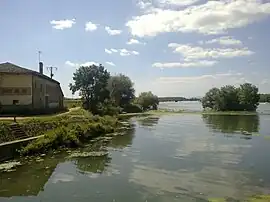 The Saône | |
.svg.png.webp) Coat of arms | |
Location of Grièges | |
 Grièges  Grièges | |
| Coordinates: 46°15′20″N 4°51′04″E / 46.2556°N 4.8511°E | |
| Country | France |
| Region | Auvergne-Rhône-Alpes |
| Department | Ain |
| Arrondissement | Bourg-en-Bresse |
| Canton | Vonnas |
| Intercommunality | Veyle |
| Government | |
| • Mayor (2020–2026) | Annick Grémy[1] |
| Area 1 | 14.87 km2 (5.74 sq mi) |
| Population | 1,901 |
| • Density | 130/km2 (330/sq mi) |
| Time zone | UTC+01:00 (CET) |
| • Summer (DST) | UTC+02:00 (CEST) |
| INSEE/Postal code | 01179 /01290 |
| Elevation | 169–212 m (554–696 ft) (avg. 268 m or 879 ft) |
| 1 French Land Register data, which excludes lakes, ponds, glaciers > 1 km2 (0.386 sq mi or 247 acres) and river estuaries. | |
Grièges (French pronunciation: [ɡʁijɛʒ]; Arpitan: Grièjo) is a commune in the Ain department in eastern France.
Geography
The Veyle forms most of the commune's northern border, then flows into the Saône, which forms the commune's western border.
Population
| Year | Pop. | ±% p.a. |
|---|---|---|
| 1968 | 1,108 | — |
| 1975 | 1,286 | +2.15% |
| 1982 | 1,423 | +1.46% |
| 1990 | 1,606 | +1.52% |
| 1999 | 1,598 | −0.06% |
| 2009 | 1,850 | +1.48% |
| 2014 | 1,908 | +0.62% |
| 2020 | 1,884 | −0.21% |
| Source: INSEE[3] | ||
See also
References
- ↑ "Répertoire national des élus: les maires" (in French). data.gouv.fr, Plateforme ouverte des données publiques françaises. 13 September 2022.
- ↑ "Populations légales 2021". The National Institute of Statistics and Economic Studies. 28 December 2023.
- ↑ Population en historique depuis 1968, INSEE
Wikimedia Commons has media related to Grièges.
This article is issued from Wikipedia. The text is licensed under Creative Commons - Attribution - Sharealike. Additional terms may apply for the media files.