Mérignat | |
|---|---|
Commune | |
 | |
Location of Mérignat | |
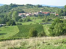
 Mérignat  Mérignat | |
| Coordinates: 46°04′13″N 5°26′15″E / 46.0703°N 5.4375°E | |
| Country | France |
| Region | Auvergne-Rhône-Alpes |
| Department | Ain |
| Arrondissement | Nantua |
| Canton | Pont-d'Ain |
| Intercommunality | Rives de l'Ain - Pays du Cerdon |
| Government | |
| • Mayor (2020–2026) | Alain Poizat[1] |
| Area 1 | 3.17 km2 (1.22 sq mi) |
| Population | 136 |
| • Density | 43/km2 (110/sq mi) |
| Time zone | UTC+01:00 (CET) |
| • Summer (DST) | UTC+02:00 (CEST) |
| INSEE/Postal code | 01242 /01450 |
| Elevation | 300–587 m (984–1,926 ft) (avg. 385 m or 1,263 ft) |
| 1 French Land Register data, which excludes lakes, ponds, glaciers > 1 km2 (0.386 sq mi or 247 acres) and river estuaries. | |
Mérignat (French pronunciation: [meʁiɲa]) is a commune in the Ain department in eastern France.
Population
| Year | Pop. | ±% p.a. |
|---|---|---|
| 1968 | 90 | — |
| 1975 | 86 | −0.65% |
| 1982 | 80 | −1.03% |
| 1990 | 85 | +0.76% |
| 1999 | 114 | +3.32% |
| 2009 | 136 | +1.78% |
| 2014 | 124 | −1.83% |
| 2020 | 136 | +1.55% |
| Source: INSEE[3] | ||
See also
References
- ↑ "Répertoire national des élus: les maires" (in French). data.gouv.fr, Plateforme ouverte des données publiques françaises. 13 September 2022.
- ↑ "Populations légales 2021". The National Institute of Statistics and Economic Studies. 28 December 2023.
- ↑ Population en historique depuis 1968, INSEE
Wikimedia Commons has media related to Mérignat.
This article is issued from Wikipedia. The text is licensed under Creative Commons - Attribution - Sharealike. Additional terms may apply for the media files.